NEXT-GEN EARTH OBSERVATION

POWERED BY aurora

Aurora, Pixxel’s in-house Earth Observation Studio, transforms satellite imagery into actionable insights, delivering a seamless satellite data analysis experience. Designed to make remote sensing accessible to everyone, Aurora empowers users to access, interpret, and leverage Earth Observation data like never before.

Explore, Analyse, and Generate

Insights on one platform

Aurora offers a vast archive of diverse open-source Earth Observation datasets, including the anticipated integration of Pixxel’s hyperspectral imagery, and a marketplace of ready-to-use models and indices in a no-code environment.

With customisable workflows, an intuitive interface, and easy implementation of analytical models, Aurora removes the steep learning curve associated with traditional software, making remote sensing data analysis more adaptable.

With Aurora, you can:

Dive into the Aurora Experience

No credit card required and no software to install

What sets Aurora apart

Aurora unlocks unprecedented opportunities in satellite data analysis for businesses, researchers, and governments. Find out what makes Aurora unique:

CLOUD-NATIVE &
INTEROPERABLE

No installations required, accessible via web browser with API access and integration with open source & third-party datasets.

ALL-IN-ONE
SOLUTION

Access multiple datasets, models, and advanced features in one place, with transparent model pricing and comprehensive documentation.

transparent
pricing

Transparent model pricing (per km²) and comprehensive documentation with visibility about model accuracy.

EXCEPTIONAL USER
EXPERIENCe

Enjoy quick onboarding, an intuitive UX, and a powerful AI Assistant for a smooth, user- friendly experience with near real time results.

get all your

needs discovered

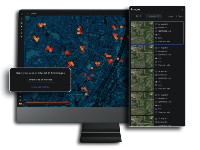
– Draw or upload AOI

– Access huge database of imagery

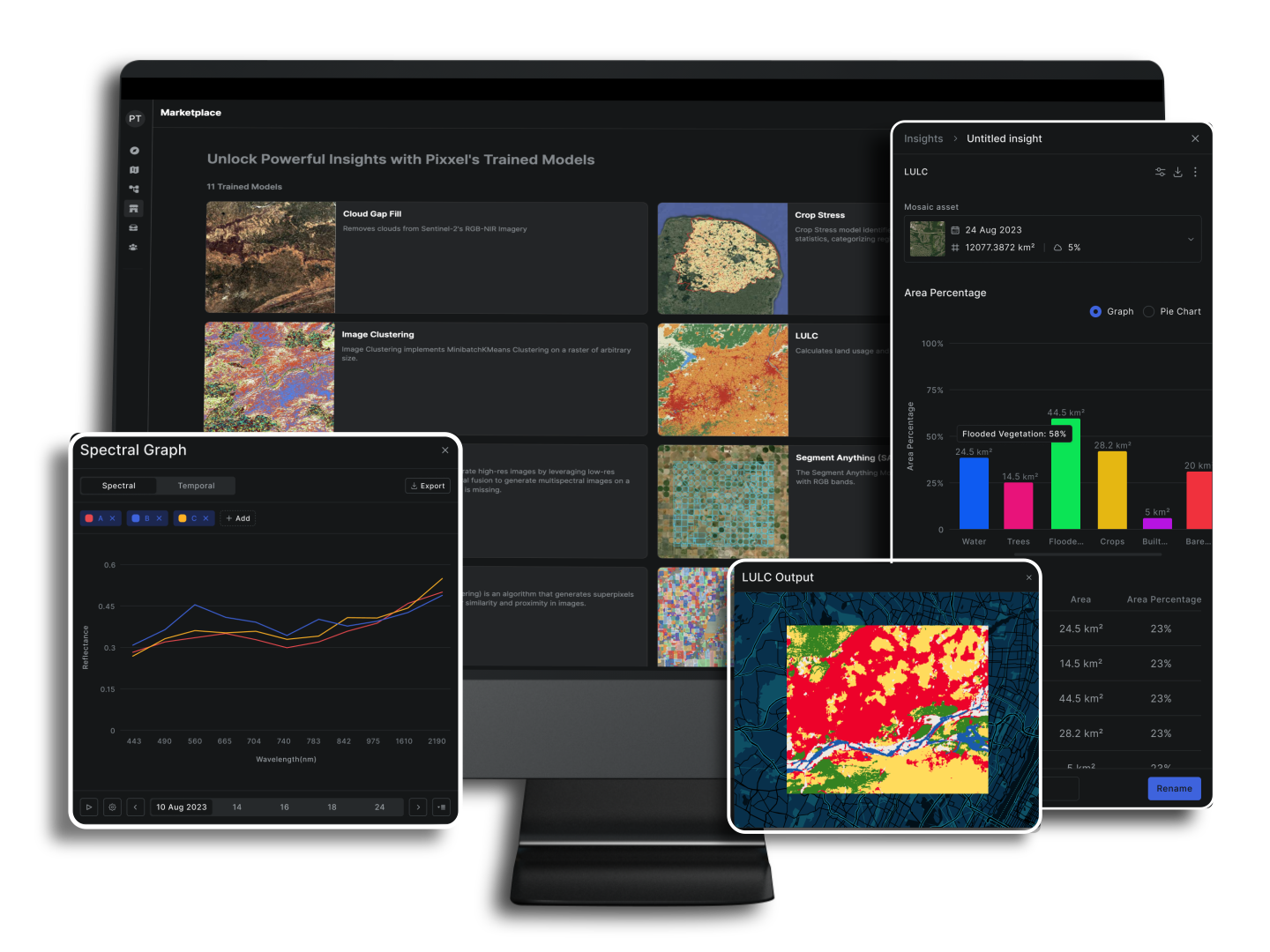
– AI / ML models marketplace

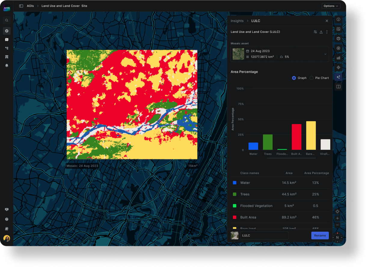
– Spectral and temporal graphs

– One click instant insights

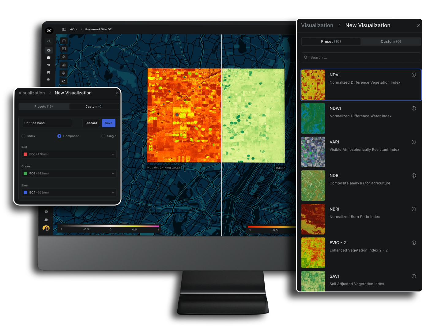
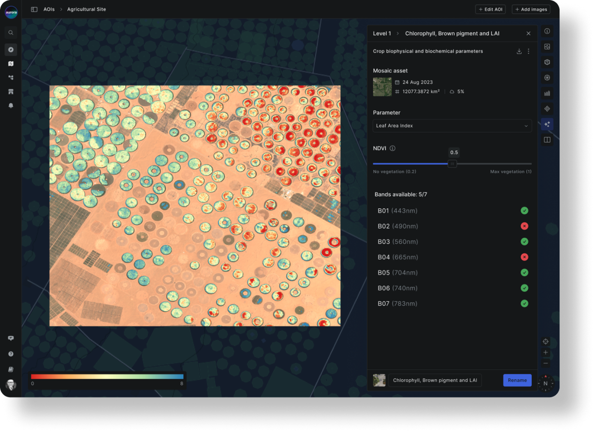
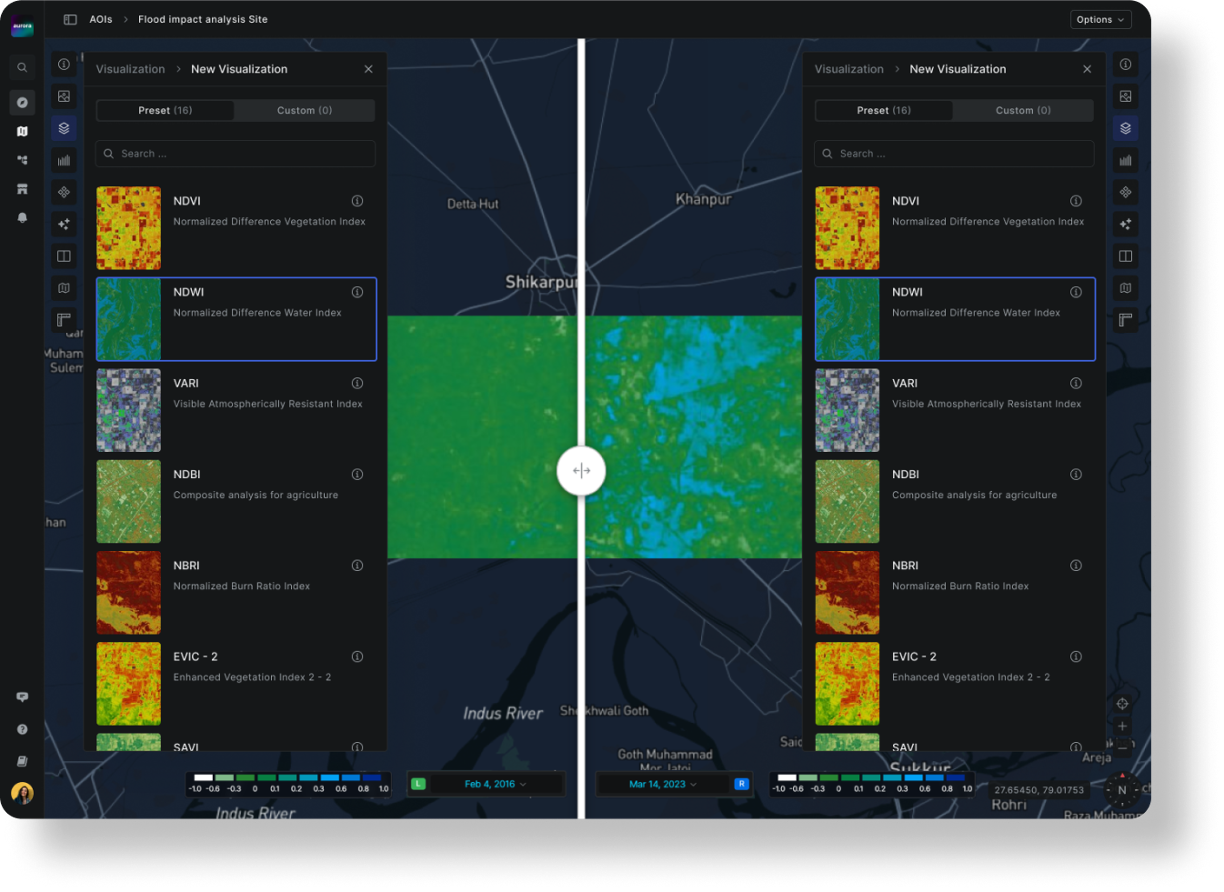
– 20+ Preset Indices like  NDVI, NDWI etc.

– Create custom indices and composites

– Split compare feature

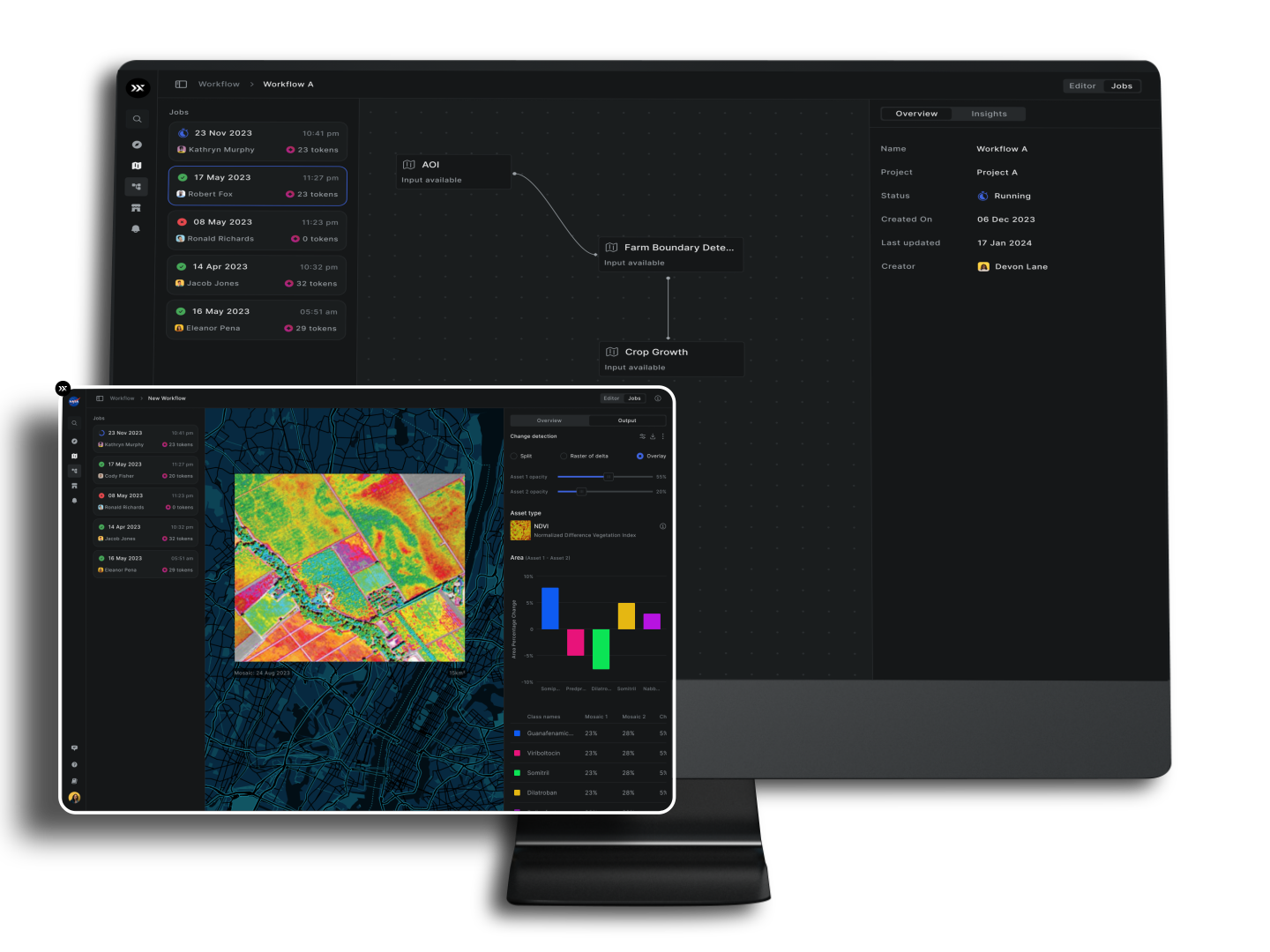
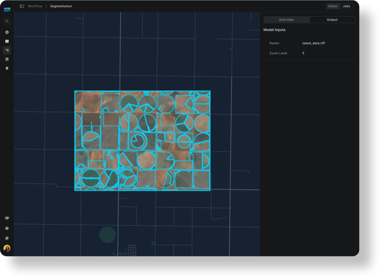
– Drag and drop processing blocks to
   create custom workflows

SOLUTIONS

TAILORED FOR YOUR INDUSTRY

Aurora is designed to meet the diverse needs across industries and use cases, providing accurate and relevant data for compliance and business requirements. This next-generation Earth Observation Studio empowers users to integrate satellite data into their core business processes, driving decision-making with unmatched precision and efficiency.


AGRICULTURE

Helps identify the individual farms, for better planning, allocation of resources, and making smart decisions for farming.

Assesses and predicts plant stress levels, which helps in identifying and addressing issues to optimize crop health and yields.

Tracks and analyzes the development of crops, which helps in making informed decisions for efficient agriculture practices to achieve better yields.

Identifies and categorizes different types of crops, assisting in precision farming and land management.

MINING

Identifies the mines in various part of the world to aid analysis for regulatory monitoring or illegal mining detection.

Maps the distribution of minerals on the Earth’s surface, assisting in mineral exploration and geological studies for resource assessment.

Monitor the structural integrity of tailings dams, ensuring early detection of potential issues for improved safety and environmental protection in mining operations.

Monitor and analyze open-pit mining activities to identify potential hazards and ensure compliance with environmental and operational standards.

environment & FORESTRY

Assesses the amount of organic material in a forest, aiding in sustainable forest management and carbon sequestration efforts.

Inspects the quality of water bodies, helping ensure safe and sustainable water resources through the analysis of various parameters such as pollutants and nutrient levels.

Tracks changes in vegetation over time, helping identify and monitor areas experiencing deforestation/afforestation for environmental conservation efforts.

Classifies the different tree species using remote sensing data which in turn help in forest resource management and biodiversity assessment.

Assess and quantify the extent of damage caused by forest fires, enabling rapid identification of affected areas and informing restoration efforts.

ENERGY

Ensure pipeline safety by monitoring vegetation growth, construction, and natural hazards along the Right of Way (RoW); detect land cover changes that could harm the pipeline and set up early warning systems for quick threat detection.

Distinguishes and tracks oil spills in water bodies, facilitating rapid response and containment efforts for environmental protection.

Detect, locate and classify pipeline leakages in a timely manner and minimize environmental and operational risks.

GOVERNMENT

Categorizes and maps different types of terrain, providing essential information for urban planning, environmental management, and natural resource monitoring.

Evaluates the extent of flooding in an area, aiding in disaster response and management by identifying affected regions for timely intervention.

Identifies and analyzes changes over time on image layers such as Land Use or Crop Stress or NDVI, etc. and generates visual maps and metrics for actionable insights across various sectors.

pricing
  • Free tokens Free tokens will be available only once at the time of org creation. For more tokens, you can anytime recharge tokens in the wallet.
  • AOI size limit
  • Tasking
  • Collaboration
  • Open source data
  • Pixxel archives
  • Analytics
  • Image exploration
  • Indices
  • Models
  • Workflows
  • Processing speed
  • Live tutorials
  • Data labelling
  • AI assistant
  • Audit logs
  • Compliance reports

Pricing

Pricing
Free tokens
AOI size limit
Tasking
Collaboration
Open source data
Pixxel archives
Analytics
Image exploration
Indices
Models
Workflows
Processing speed
Live tutorials
Data labelling
AI assistant
Audit logs
Compliance reports
Free
0
200 km²
✓
✓
✓
✓
✓
✓
✓
✓
✓
Standard
-
-
-
-
-
Pricing
Free tokens
AOI size limit
Tasking
Collaboration
Open source data
Pixxel archives
Analytics
Image exploration
Indices
Models
Workflows
Processing speed
Live tutorials
Data labelling
AI assistant
Audit logs
Compliance reports
$135
/seat/month, billed annually $150/seat/month
150
5000 km²
✓
✓
✓
✓
✓
✓
✓
✓
✓
Standard
2 hours/month
Coming soon
-
-
-
Pricing
Free tokens
AOI size limit
Tasking
Collaboration
Open source data
Pixxel archives
Analytics
Image exploration
Indices
Models
Workflows
Processing speed
Live tutorials
Data labelling
AI assistant
Audit logs
Compliance reports
$180
/seat/month, billed annually $200/seat/month
300
5000 km²
✓
✓
✓
✓
✓
✓
✓
✓
✓
Speed Boost
6 hours/month
Coming soon
Coming soon
Coming soon
Coming soon

Experience the Future of

Earth Observation with Aurora

Unlock a unified platform that simplifies hyperspectral and Earth observation data analysis, empowering communities to seamlessly integrate these insights into their decision-making processes.

KNOWLEDGE HUB

Discover how Pixxel's Earth Observation technology drives impactful insights.